A diffusion-based foundation model downscaling global 0.25° forecasts to 1 km hourly fields of eight coupled near-surface variables over a 67-hour window.
Somnath Luitel*, Manmeet Singh* · Joshua Durkee · Abdullah Al Fahad · Naveen Sudharsan ·
Prabhjot Singh · Cenlin He · Harsh Kamath · Zong-Liang Yang · Amit Kumar Srivastava ·
Krishnagopal Halder · Sandeep Juneja · Parthasarathi Mukhopadhyay · Saptarishi Dhanuka
* Equal contribution | Correspondence: manmeet.singh@wku.edu
Abstract
AI weather models now match operational forecasts at 25 km resolution, yet the kilometer-scale fields needed
for renewable energy, agriculture, hydrology, and disaster response remain the exclusive domain of expensive
convection-permitting numerical weather prediction (NWP). We introduce AiRCast-SR, a diffusion-based
foundation model that downscales global 0.25° GraphCast forecasts to 1 km hourly fields of eight coupled
near-surface variables over a 67-hour window.
Trained on a single calendar year of NOAA Analysis of Record for Calibration (AORC) data over the contiguous
United States using patch-based supervision, the model resolves mesoscale structure verified by spectral
analysis, maintains near-zero systematic bias, and generalises zero-shot to India and Germany without
retraining. AiRCast-SR reaches comparable skill to the operational High-Resolution Rapid Refresh (HRRR)
on commodity GPUs — establishing a scalable, open-weights foundation for kilometer-scale weather services.
Capabilities
Model Highlights
The first AI weather model combining global scope, 1 km resolution, hourly cadence, and commodity-GPU deployment.
1 km
Kilometer-Scale Resolution
Generates 1 km hourly fields — a 28× spatial refinement over 0.25° GraphCast input — resolving valley cold pools, lake-effect gradients, and terrain-modulated contrasts.
Global
Zero-Shot Transfer
Patch-based foundation training enables deployment over arbitrary domains worldwide without retraining — verified over India (r = 0.88) and Germany with near-zero bias.
8 vars
Multivariate Consistency
All eight near-surface variables — temperature, humidity, winds, pressure, radiation, precipitation — produced jointly in a single forward pass.
1 GPU
Commodity Inference
Full CONUS 67-hour 8-variable forecast in minutes on a single NVIDIA A100 or comparable GPU. Utilizes 4–25 LCM denoising steps.
Under the hood
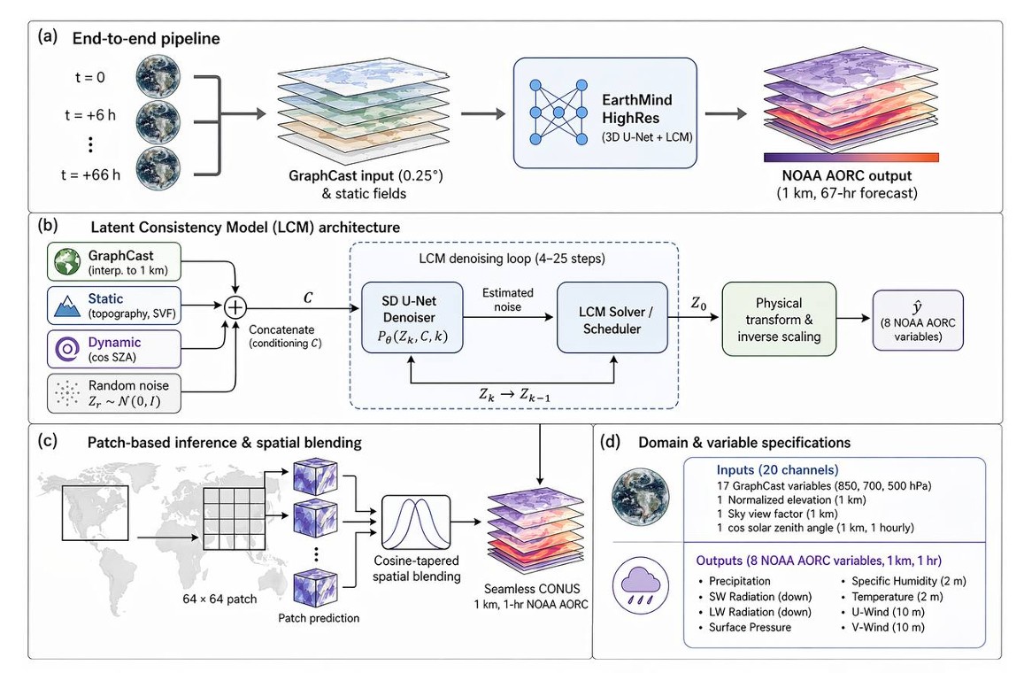
Architecture
AiRCast-SR employs a 3D U-Net denoiser within a
Latent Consistency Model (LCM) diffusion framework. The 3D architecture jointly
processes spatial (1 km) and temporal (hourly) dimensions, maintaining physical coherence across
all eight output variables and 67 forecast hours.
Twenty conditioning channels — 17 GraphCast atmospheric fields at three pressure levels,
normalised topography, sky-view factor, and the cosine of solar zenith angle — drive the
downscaling. The LCM objective compresses iterative diffusion sampling into 4–25 consistency
steps, enabling full-CONUS inference in minutes.
Backbone
UNet3DConditionModel (HuggingFace)
Input channels
28 (8 target + 20 conditioning)
Output channels
8 near-surface variables
Diffusion schedule
1000 training timesteps
Inference steps
4 – 25 LCM solver steps
Patch size (infer)
256 × 256 · 50% overlap
Figure 1: High-level atmospheric super-resolution workflow, Latent Consistency Model (LCM) schematic, and patch-based spatial blending strategy.
Evaluation
Performance across regimes
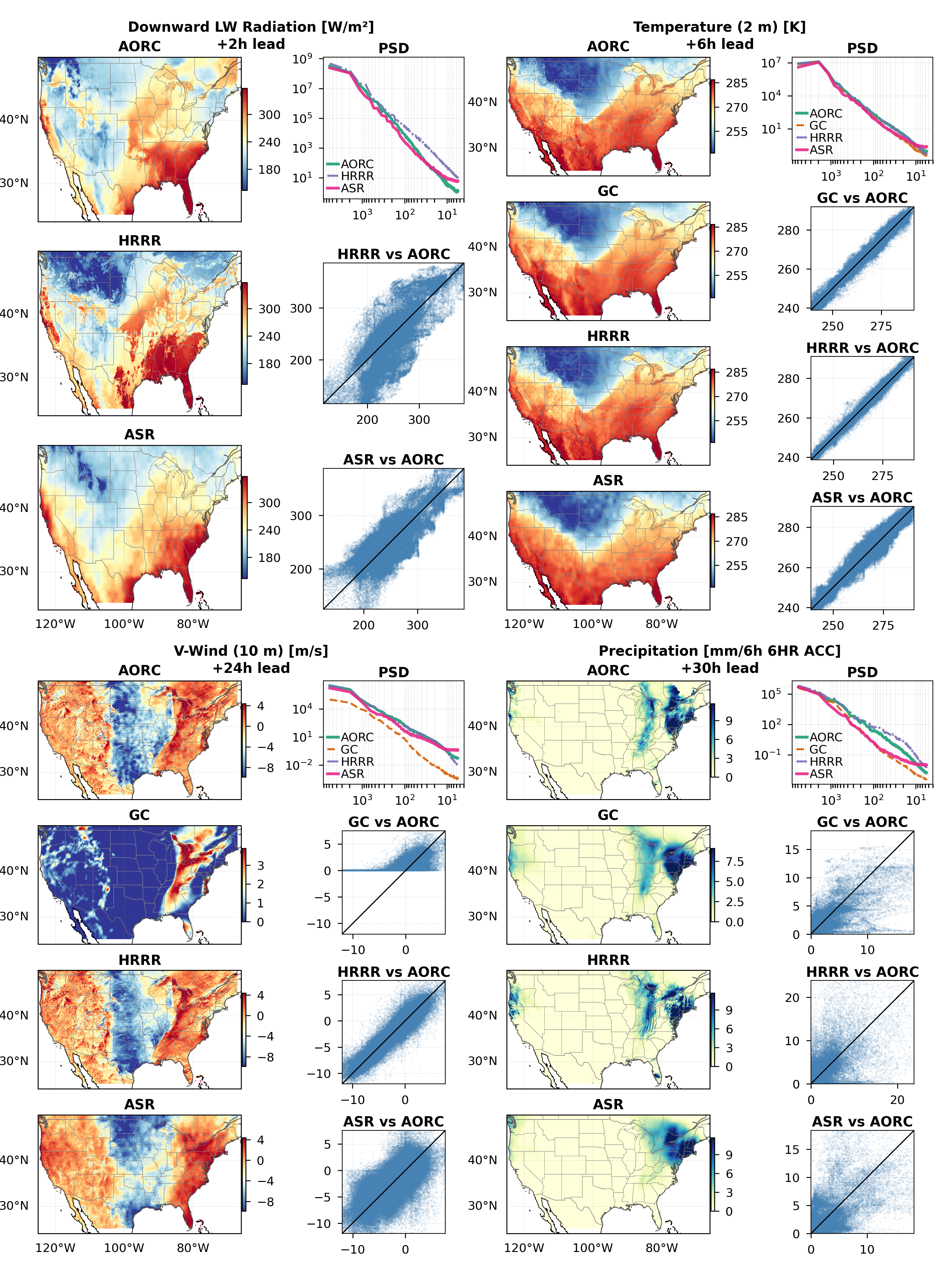
Evaluated on three CONUS case studies against AORC reference truth, operational HRRR (3 km), and raw GraphCast input.
r = 0.97
2-m Temperature
Winter case, 6 h lead
< 0.01 K
Systematic Bias
All cases, all leads
r = 0.74
Precipitation
Winter, 18 h lead
Winter Extreme
Winter Storm Elliott
December 22, 2022
A continental-scale cold-air outbreak with arctic front and blizzard conditions. AiRCast-SR effectively resolved mesoscale thermal structures below the −9°C de-icing threshold.
Summer Extreme
Summertime Convection
June 12, 2022
Mesoscale convective systems over the central US. AiRCast-SR outperforms HRRR beyond 12-hour lead on precipitation (r = 0.39–0.43 vs HRRR r = 0.09–0.26).
Spring Transition
Frontal Passage
March 31, 2023
Synoptic-scale frontal passage during spring transition, demonstrating AiRCast-SR across a broad dynamical regime spanning temperature and precipitation extremes.
Figure 2: Multipanel evaluation for Winter Storm Elliott (Dec 22, 2022). Comparing AORC (ground truth), raw GraphCast input, operational HRRR, and AiRCast-SR (ASR) across Downward LW Radiation, Temperature, V-Wind, and Precipitation. PSD and scatter plots highlight AiRCast-SR's structural fidelity and zero-bias capability.
Spectral fidelity & perception–distortion
AiRCast-SR's power spectral density tracks the AORC reference from 1000 km down to 10 km wavelengths
for temperature — while GraphCast rolls off sharply below 100 km. This spectral realism is the operational signature required for downstream hydrological, energy-system, and hazard-nowcasting applications.
Foundation model generality
Zero-shot global transfer
Without any retraining, AiRCast-SR was evaluated against StationBench surface observations over two climatologically distinct regions.
🇮🇳 India
March 2023 · 524 stations
A striking result for a model trained exclusively on CONUS data. AiRCast-SR resolves Himalayan cold-temperature signals
and Indo-Gangetic thermal gradients at 1 km resolution with near-zero bias.
r = 0.83–0.89
2-m Temp Correlation
< 0.006 K
Max Systematic Bias
🇩🇪 Germany
August 2023 · 1,338 stations
Central Europe has weaker orographic gradients—informatively, skill is lower here than over India. This confirms that AiRCast-SR has learned topographic forcing as a transferable physical relationship.
r = 0.37–0.70
2-m Temp Correlation
< 0.001 K
Max Systematic Bias
Resources & People
Open Science & Team
🤗 Hugging Face Weights
Download the open-source model weights directly from our Hugging Face repository. Ready for immediate deployment and fine-tuning.
Western Kentucky UniversityNASA Goddard Space Flight CenterUniversity of Texas at AustinNSF NCARZALF · BerlinAshoka University
Cite this work
Citation
BibTeX
@article{luitel2026aircastsr,
  title     = {A Diffusion-Based Foundation Model for Global
               Kilometer-Scale Hourly Weather Prediction},
  author    = {Luitel, Somnath and Singh, Manmeet and Durkee, Joshua
               and Al Fahad, Abdullah and Sudharsan, Naveen
               and Singh, Prabhjot and He, Cenlin and Kamath, Harsh
               and Yang, Zong-Liang and Srivastava, Amit Kumar
               and Halder, Krishnagopal and Juneja, Sandeep
               and Mukhopadhyay, Parthasarathi and Dhanuka, Saptarishi},
  journal   = {TBD},
  year      = {2026},
  url       = {https://github.com/Air-Lab-WKU/AiRCast-SR},
  note      = {AiRCast-SR; open-weights foundation model
               for kilometer-scale weather downscaling}
}